Municipal Identity
Geographical location, historical background, and natural resources
2.1 Geographical Location
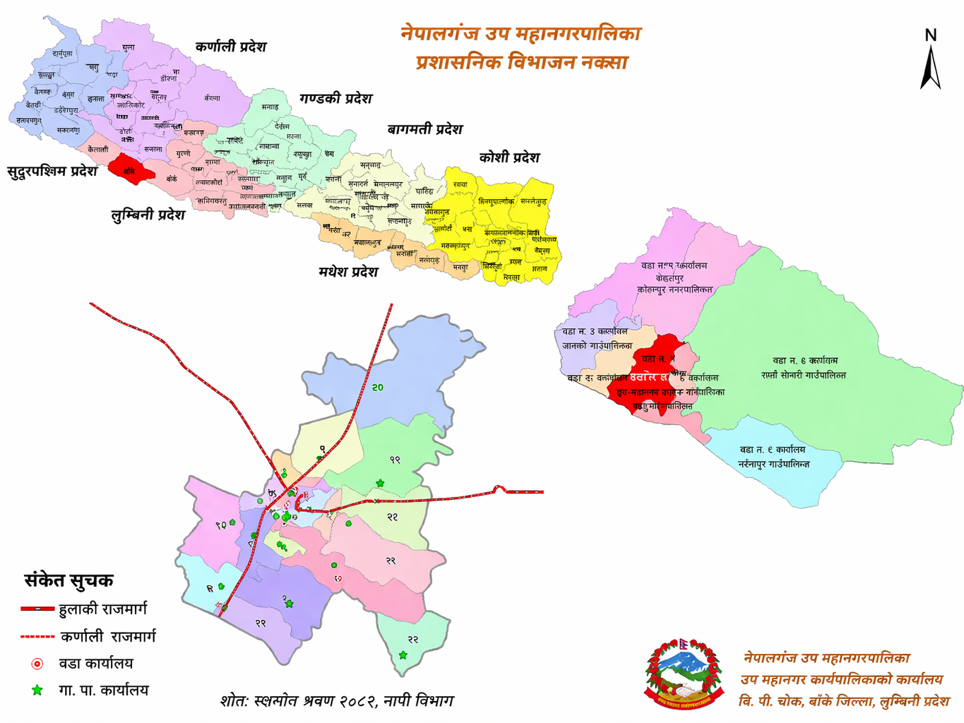
Nepalgunj Sub-Metropolitan City is located in Banke District within Lumbini Province. It lies between 28° 02' 48" N to 28° 07' 12" N latitude and 81° 35' 24" E to 81° 41' 24" E longitude. It sits at an elevation of approximately 150 meters above sea level.
The sub-metropolis is bounded by Duduwa Rural Municipality to the east, Khajura Rural Municipality to the west, Janaki Rural Municipality to the north, and the Indian state of Uttar Pradesh to the south. Its total area is 85.94 square kilometers.
2.2 Historical Background and Naming
Banke, Bardiya, Kailali, and Kanchanpur were returned to Nepal by the British government around 1917 B.S. as a gesture of gratitude for the assistance provided by Prime Minister Jung Bahadur Rana. This territory became known as 'Naya Muluk' (New Country). The market of Nepalgunj was established during this period. The name 'Nepalgunj' is derived from 'Nepal' and 'Gunj' (meaning market).
Since its historical origins, the city has evolved as a vital commercial hub. Recognized as the primary gateway to Western Nepal, it is celebrated as a center of religious tolerance and communal harmony.
2.3 Political and Administrative Structure
Nepalgunj Municipality was established in 2017 B.S. according to historical records. Following the declaration of the sub-metropolis on 2071/08/16 B.S., 28 former wards were consolidated into the current 13 wards. This administrative restructuring reflects the city's expansion and its central role in the federal governance system of Nepal.
| Ward No. | Included Former Wards/VDCs | Area (sq. km.) | Center |
|---|---|---|---|
| 1 | Nepalgunj Mun. former 7, 8 | 1.05 | Dhamboji |
| 2 | Nepalgunj Mun. former 9, 10 | 0.64 | Gharbari Tole |
| 3 | Nepalgunj Mun. former 11, 12, 25 | 1.11 | Eklaini |
| 4 | Nepalgunj Mun. former 13, 14, 15, 16, 22 | 1.35 | Ganeshpur |
| 5 | Nepalgunj Mun. former 1, 2, 3, 4, 5, 6 | 0.75 | New Road |
| 6 | Nepalgunj Mun. former 17, 18, 19 | 0.98 | Phultekra |
| 7 | Nepalgunj Mun. former 20, 21 | 0.94 | Gaganpur |
| 8 | Nepalgunj Mun. former 23, 24, 26 | 1.12 | Mahendra Park |
| 9 | Nepalgunj Mun. former 27, 28 | 1.15 | Eye Hospital |
| 10 | Nepalgunj Mun. former 3, 5 | 3.44 | Brikuti Nagar |
| 11 | Nepalgunj Mun. former 10, 11 | 3.95 | Karkando |
| 12 | Nepalgunj Mun. former 13 | 5.21 | Belaspur |
| 13 | Nepalgunj Mun. former 14, 15 | 6.82 | Udayapur |
Map No. 1: Administrative Division Map
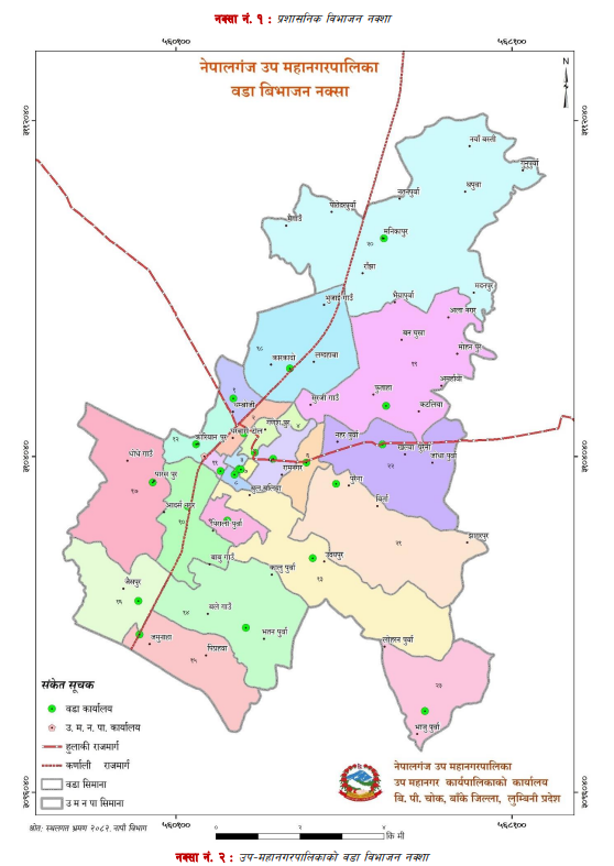
Map No. 2: Ward Division Map
2.4 Terrain
Description of the terrain is a crucial element when reporting on a sub-metropolis's physical conditions. Nepal, while small in area, possesses a globally distinguished geographical diversity. The current land surface of Nepal was formed by the collision of the Indian Plate and the Tibetan Plate, eliminating the Tethys Sea. This sub-metropolis sits atop a segment of the fertile Gangetic plain, a topographical feature that plays a decisive role in regional planning and sustainable infrastructure development.
A) Soil Composition
The geological structure of this sub-metropolis is primarily silt-mixed and highly fertile. Regions adjacent to rivers and streams tend to have sandier soil, while inner areas are characterized by clay-loam rich in organic matter. This soil profile is exceptionally well-suited for intensive agricultural production.
B) Slope Analysis
Land classification in Nepalgunj is categorized by its suitability for agriculture and its susceptibility to soil erosion. Given its location in the Terai region, much of the sub-metropolis is flat, presenting minimal slope diversity.
Slope 0°-5°: Sufficient soil depth and excellent drainage define this category. While traditional and modern farming are both viable, maintaining surface water management is necessary to prevent gully formation.
Slope 5°-10°: While fertile, land in this range requires careful embankment management to prevent soil movement. Forest and vegetation are generally the preferred land uses here.
Slope 30°-40°: Comprised of thin soil layers (approx. 20 cm) and steep gradients, this land category is most effectively used for protective vegetation and timber production to mitigate the risk of landslides.
Slope > 40°: Highly steep land with very shallow soil layers. Conservation through permanent greenery (trees or shrubs) is mandatory to ensure environmental stability.
C) Aspect Description
A detailed analysis concerning the land's aspect is presented below, detailing how orientation and sunlight influence agricultural and settlement patterns.
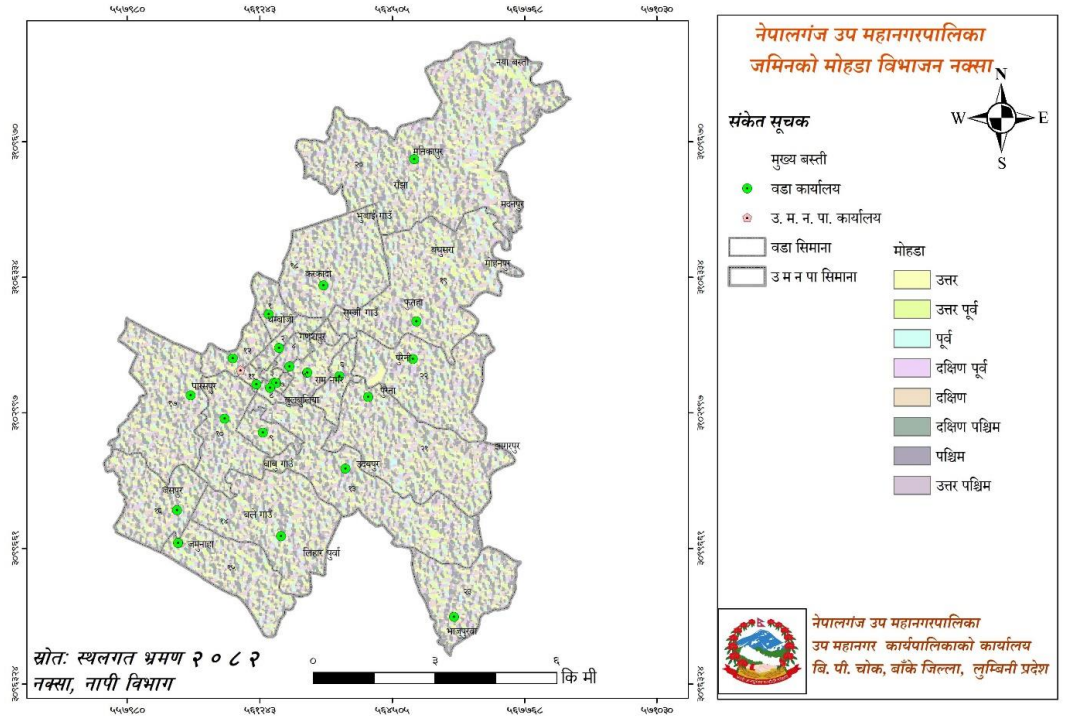
Map No. 3: Map of Sub-Metropolitan City
Land slope and aspect are generally complementary to each other. This means that when the slope is irregular, the aspect also tends to be irregular. Although there is no significant diversity in aspect in flat areas, the following is the aspect description for the sub-metropolis:
| Aspect (Facing) | Area (sq. km.) | Area (Percentage) |
|---|---|---|
| North | 11.69 | 13.60 |
| North-East | 10.12 | 11.77 |
| East | 9.89 | 11.50 |
| South-East | 11.35 | 13.21 |
| South | 11.48 | 13.35 |
| South-West | 10.65 | 12.40 |
| West | 10.06 | 11.71 |
| North-West | 10.71 | 12.46 |
2.5 Natural Resources
The primary basis for the development of any region is the natural resources available there. Natural resources include locally available land, forests, flora, fauna, herbs, mines and minerals, rivers, streams, lakes, mountains, waterfalls, watershed areas, wetlands, parks, reserves, and protected areas. Only by ensuring the sustainable and wise utilization of these natural assets can we achieve prosperity.
2.6 Cultural Excellence
Human habits, language, behavior, and daily life are guided by specific traditions in an abstract way. To carry out daily activities, people are bound within the framework of family and society. Traditions establish kinship through marriage and this creates a family. Birth, death, marriage, food, dress, festivals, language, and lifestyle all fall within cultural characteristics. These dimensions of civilization and culture are the major aspects of human identity. Cultural activities help people live a refined life. It makes society organized and dynamic.
According to the 2078 National Census, 113,028 people, or 68.7%, in the Sub-Metropolitan City are Hindus. Similarly, 48,251, or 29.3%, are Muslims, 1,154, or 0.7%, are Buddhists, and 1,432, or 0.9%, are Christians. The followers of these religions celebrate festivals such as Dashain, Tihar, Ram Navami, Maha Shivaratri, Haritalika, Shree Panchami, Janmashtami, Holi, Chaite Dashain, Sankranti, Mother's Day, Akshay Tritiya, Ekadashi, Nag Panchami, Raksha Bandhan, Father's Day, Bala Chaturdashi, New Year, Chhath, Christmas, Eid, and Bakra-Eid.
People of various castes, religions, sects, and attires live in this Sub-Metropolitan City. Each has its own unique religion, culture, and customs. In this Sub-Metropolitan City, where the Muslim and Chhetri communities are predominant, during festival times, Chhetris wear traditional attire like Ganyu, Cholo, and Patuka, while Muslim women wear Saree-Blouse, Kurta-Suruwal, Burqa, or Hijab, and men wear Jubba or Suruwal-Kurta. However, in modern times, youth of all communities increasingly prefer wearing pants, shirts, t-shirts, and other modern clothing.
2.7 Key Development Possibilities
Every location has its unique characteristics. In some areas, forest land is excessive, while others have plenty of water resources or are dry. Therefore, in agricultural areas, upgrading can be done through commercialization, while in forest-rich areas, prosperity can be achieved through sustainable forest management. Potential can be explored based on available sources and tools. Here, cultivable land stands at 80.14%. Prosperity can be achieved through a scientific agricultural system.
Sustainable forest management involves taking care of and improving forest areas like harvestable crops. Potential and opportunities within the Sub-Metropolitan area include traditional and modern agriculture, herbs, tourism, animal husbandry, and small and medium-scale industrial development. Furthermore, there are ample opportunities to develop parks, gardens, and religious heritage sites as tourist attractions.
In the cultivable land within the Sub-Metropolitan area, there are abundant possibilities to increase production of food grains, other cash crops, vegetables, fruits, pulses, spices, and herbs, as well as animal-related production. Due to the lack of modern agricultural technology, fertilizers, and tools, as well as their maximum cost price, their use has been limited and agricultural production hasn't increased as required. There are abundant possibilities to improve the economic situation through awareness, skills, commercialization, modernization, technology transfer, and simplified availability of needed tools, fertilizers, loans, and seeds.
With abundant potential for dairy and livestock production in rural areas of the Sub-Metropolitan area, expanding these businesses and extending transport services conveniently to their reach can help develop dairy chilling centers, agricultural collection centers/cold storage, and meat-related industries. This offers a significant opportunity to create employment and increase the overall income of the Sub-Metropolitan City.
Remarkable increase in agricultural production can be achieved by utilizing underground water sources and rivers through modern canals and irrigation systems for commercial farming.
By upgrading and blacktopping local gravel roads, local residents can fully benefit from such facilities, and it can also upgrade living standards and enhance the beauty of the entire Sub-Metropolitan City.
Abundant possibilities for tourism development exist, as there are various historical, religious, and cultural sites within this area.
Government, non-government, and private organizations active in the area appear as potential partners in the Sub-Metropolitan City's development.
Industrial, trade, and commercial development potential is emerging in the context of increasing consumers within the Sub-Metropolitan area.
2.8 Household Production
Gross Domestic Product (GDP) is a measure that reflects the overall economy of a country. It represents the total final transaction value of goods and services produced within a country or a place over a specific period. It includes all private and public consumption, government spending, investment, materials in stock, expenses during construction, and expenses and income from imports and exports. In Nepal, this is calculated annually. According to Trading Economics, in 2023, Nepal's GDP was approximately 40 trillion rupees, and its per capita income was 1,399 US dollars.
2.9 Human Development Index
According to the United Nations Development Programme (UNDP) 2025 report, Nepal's human development index is 0.622, ranking Nepal 145th among 193 countries in the world. Among these countries, Nepal last year was in 146th position, but this year it rose one place. In 1990, the human development index of Nepal was 0.398. During that period, the average life expectancy of Nepalis was 70.4 years. Similarly, according to the second periodic plan 80/81 of Lumbini Province, the human development index is 0.563, and the average life expectancy is 69.5 years. Poverty distribution details are included in the table below.
| Province | Multidimensional Poverty Rate (%) | Poverty (%) | Headcount (%) | Poverty Intensity (%) | Number of Poor | Human Development Index |
|---|---|---|---|---|---|---|
| Lumbini Province | 29.9 | 24.8 | 6.5 | 2.3 | 1,053,379 | 0.468 |