Forest and Environmental Status
Forest area, water resources, biodiversity, and disaster risk management
6.1 Forest Area Status
Although there are no forest areas within the total land area of the sub-metropolitan city, 2.61 percent of the land area is covered by bush and shrubland. Goal No. 15 of the Sustainable Development Goals (SDGs) highlights the importance of sustainable management of forests, combating desertification, halting and reversing land degradation, and halting biodiversity loss. Therefore, to maintain the balance of the environmental system, cleanliness of the atmosphere, and habitats for flora and fauna, the conservation of forests must be prioritized. Moreover, by extensively involving the public in plantation programs on fallow lands and riverbanks outside forest areas, the sub-metropolitan city can be developed as a 'green garden,' linking forests to income generation even in limited amounts. Similarly, it seems necessary to conduct plantation, dam construction, wire fencing, embankment, and traditional flood/inundation control and soil conservation programs in highly sensitive areas. Since plantation is an effective measure for soil conservation, prioritizing this task is essential.
6.1.1 Forest Management Description (Government-managed, Community, Leasehold, Religious, and Private Forest)
a. Community Forest
A community forest refers to a national forest handed over to a user group for the development, conservation, and utilization for collective benefit. According to the Nepal Government's policy of involving local residents in forest conservation and utilization, the District Forest Office has been forming Community Forest User Groups and handing over forests in this sub-metropolitan city as well.
When this program was initially implemented, the objective was to increase greenery on bare hills and slopes and to fulfill basic needs for timber, fuel-wood, and fodder for the general public. However, the program now includes new issues like poverty alleviation, livelihoods, and biodiversity conservation. Over the past few years, there has been a new awakening among the public living around forest areas. As a result of the concern for their own community forests, areas that were bare, facing desertification, or affected by streams and torrents are now naturally conserved.
To make forest management effective, it is essential to ensure community forests have access to sources, resources, and technically skilled manpower. In addition to traditional forest conservation methods among users, it is necessary to develop new methods and work styles. The details of community forests registered in this sub-metropolitan city are mentioned below.
| S.N. | Name of Community Forest | Current Address | Area (Ha) |
|---|---|---|---|
| 1 | Pashupati Community Forest User Committee | Nepalgunj 20 and 19 | |
| 2 | Jhora Community Forest User Committee | Nepalgunj 21 | |
| 3 | Hazrat Community Forest User Committee | Nepalgunj 23 |
b. National Forest
National forest refers to a forest-related work plan prepared to develop, conserve, and utilize or sell forest products while maintaining environmental balance. National forests include all forests within Nepal, whether they have marked boundaries or not, excluding private forests.
c. Block Forest (Chakala Wan)
Block forest refers to any part of a government-managed forest with an area of at least five hundred hectares.
d. Collaborative Forest (Sajhedari Wan)
Collaborative forest refers to any part of a national forest managed in partnership with the Division Forest Office, local level, and users.
e. Religious Forest
Religious forest refers to a national forest handed over to any religious institution, group, or community for the development, conservation, and utilization of the forest.
f. Private Forest
Private forest refers to a forest raised or conserved on private land owned by an individual according to current laws.
g. Leasehold Forest (Kabuliyati Wan)
Leasehold forest refers to a national forest leased out according to current laws to any established institution, any industry based on forest products, or any community to achieve various objectives. Leasehold forests are separated to achieve objectives as follows:
(a) To produce raw materials required for forest product-based industries,
(b) To increase forest product production through plantation for sale or utilization,
(c) To conduct tourism businesses,
(d) To conduct agro-forestry operations,
(e) To conduct insect and wildlife farming.
6.1.2 Details of Available Space for Plantation
The banks of rivers and streams like the Duduwa River, playgrounds, community forest areas, etc., within this sub-metropolitan city are available as empty spaces for plantation.
6.1.3 Details of Herbal Production, Collection, and Export
Various types of medicinal herbs are found in the Nepalgunj sub-metropolitan city area. The details of important local medicinal herbs found here are presented in the table below.
| S.N. | Nepali Name | English Name | Scientific Name |
|---|---|---|---|
| 1 | Asuro | Malabar nut | Adhatoda vasica Nees |
| 2 | Aduwa | Ginger | Zingibar officinale Rose |
| 3 | Aank | Madar | Calotropis procera |
| 4 | Karela | Bitter Gourd | Memordia charantia Linn. |
| 5 | Kagati | Lemon | Citrus aurantifolia (Christm) Swingle |
| 6 | Kans | Thatch grass | Saccharum spontareum Linn. |
| 7 | Kurilo | Asparagus | Asparagus racemosus Willd. |
| 8 | Kush | Kus-grass | Desmostachya bipinnata Staff |
| 9 | Kera | Banana | Musa parasiciaca Linn. |
| 10 | Gurjo | Tinosphora cordifolia Willd Miers | |
| 11 | Gulaf | Rose | Rosa sp. |
| 12 | Ghanti phul (Barhamas) | China rose | Hibiscus rosa-sinensis Linn. |
| 13 | Ghodatabre | Water pennywort | Centella asistica (Linn.) Vrbm |
| 14 | Ghyukumari | Aloe | Aloe barbadensis Mill |
| 15 | Chari amilo | India sorrel | Oxalis carniculata Linn. |
| 16 | Titepati | Mug-wort | Artemisia vulgaris Linn. |
| 17 | Tulasi | Holy basil | Ocimum sanctum Linn. |
| 18 | Dudhesar | Euphorbia thymifolia L | |
| 19 | Dubo | Conch grass | Cynodon dactylon Pers |
| 20 | Dhaturo | Datura | Datura metel Linn. |
| 21 | Dhaniya | Coriander | Corienfrum sativum Linn. |
| 22 | Dhageri | Fire flame bush | Woodforbia fruiticosa Kutz. |
| 23 | Simall (Nirgundi) | Fire-leaved chaste | Vitex negundo Linn. |
| 24 | Neem | Neem tree | Azadhiracta indica A.Juss |
| 25 | Parijat | Night Jusmine | Nyctantanthes arbor-tristis Linn |
| 26 | Palungo | Spinas | Spicia oleracea Linn. |
| 27 | Pipla | Long pepper | Piper longum Linn. |
| 28 | Pudina | Garden mint | Mentha spicata Linn. |
| 29 | Bihi | Solanum indicum Linn. | |
| 30 | Bethe | Lambs quarters | Chenopoidium album L |
| 31 | Bojho | Sweet flag | Acorus calamus Linn. |
| 32 | Mula | Radish | Raphanus sativus Linn. |
| 33 | Mothe | Nut Grass | Cyperus rotundus Linn. |
| 34 | Lajjawati | Sensitive plant | Mimosa pudica Linn. |
| 35 | Lasun | Garlic | Allium sativum Linn. |
| 36 | Lunde | Pickly amaranth | Amaranthus spinosus L. |
| 37 | Sarpagandha | Serpentina | Rauwolfia serpentine Bethex Kurz |
| 38 | Sayapatri | Marigold | Tagetus erecta Linn. |
| 39 | Sidhure | Kamala | Mallotus Phillipinensis Muell.Arg. |
| 40 | Sup | Dill | Anethum sowa Kurz |
| 41 | Haledo | Turmeric | Curcuma longa Linn. |
6.2 Water Resources and Watershed
The streams and rivulets, including the Duduwa stream, located in this sub-metropolitan city, are the main sources of local watersheds. More than 18 natural ponds and lakes, including the Duduwa stream, Rapti river, and Waterpark pond, Phulteka pond, Rani Pond, Futaha pond, Kanti pond, Pakaniya pond, Bhatarawanwa pond, and Suiya pond, are the main sources of water in this sub-metropolitan city.
6.2.1 Major Rivers and Streams
The streams and rivulets spread across various geographical areas and wards of the sub-metropolitan city provide abundant water storage as well as shelter as a safe habitat for various types of aquatic animals and birds. Additionally, animals drink water from these streams, and farmers occasionally use the water for partial irrigation. Along with the development of human settlements and the pressure of migration, excessive grazing by unproductive animals and utilization are leading to soil erosion and the gradual filling up of natural rivers and streams.
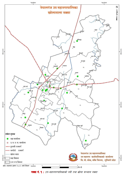
Map of Rivers and Streams in Nepalgunj Sub-Metropolitan City
| S.N. | Rivers and Streams in the City | Address |
|---|---|---|
| 1. | Duduwa River | |
| 2. | Rapti River |
| S.N. | Name of Lakes, Ponds, and Wetlands | (Number of Ponds) | Ward No. |
|---|---|---|---|
| 1. | Waterpark Pond | 1 | 1 |
| 2. | Phulteka Pond | 1 | 6 |
| 3. | Rani Pond | 1 | 8 |
| 4. | Futaha Pond | 1 | 19 |
| 5. | Kanti Pond | 1 | 22 |
| 6. | Pakaniya Pond | 1 | 15 |
| 7. | Bhatarawanwa Pond | 1 | 15 |
| 8. | Suiya Pond | 1 | 15 |
| 9. | Gahaha Pond | 1 | 15 |
| 10. | Pripahwa Pond | 1 | 15 |
| 11. | Paschim Pond | 1 | 15 |
| 12. | Idgah Pond | 1 | 16 |
| 13. | Kanti Pond | 1 | 22 |
| 14. | Lakdhawa Pond | 1 | 18 |
| 15. | Muniya Pond | 1 | 20 |
| 16. | Khaiju Pond | 1 | 20 |
| 17. | Marghatiya Pond | 1 | 20 |
| 18. | Pandit Pond | 1 | 20 |
6.3 Biodiversity and Environmental Service
6.3.1 Important Animals and Birds Based on Habitat
a) Major Wildlife
Major wildlife found in this sub-metropolitan city include rabbits, monkeys, foxes, porcupines, and others.
b) Reptiles and Amphibians
Reptiles and amphibians found in this sub-metropolitan city especially include snakes, water snakes, lizards, monitor lizards, and frogs.
c) Insects and Small Creatures
Butterflies, grasshoppers, dragonflies, crickets, fireflies, wasps, bees, spiders, mites, and centipedes are among the insects and small creatures found here.
6.3.2 Important Vegetation Details
As the forest area in the sub-metropolitan city is very negligible, there is a lack of vegetation typically found in forest areas. Therefore, in addition to bushes and shrubs, there is availability of fruit trees and plants.
6.4 Disaster Risk Management
The sub-metropolitan city faces recurring disasters like flooding, pandemics, hailstorms, strong winds, cold waves, and wild animal attacks. Recently, post-COVID-19, dengue has emerged as a major disaster. Additionally, road accidents, cold waves, and heatwaves are subsidiary disasters. The risk of earthquakes can never be ruled out. Floods and erosion from rivers and seasonal streams flowing south from the northern Chure hills cause significant loss of life and property in this sub-metropolitan city. It also severely impacts seasonal crops, off-season vegetable farming, and riverbed (bagar) farming.
Management and repair of unpaved roads, streams, culverts, and irrigation canals within the sub-metropolitan city can reduce the impact of uncontrolled floods caused by the Duduwa and Rapti rivers. For disaster risk reduction, the sub-metropolitan city has prioritized policy arrangements, awareness, and capacity-building programs, as well as prevention and emergency preparedness activities for vulnerable communities and all residents.
Basically, human activities concentrated around the streams of the sub-metropolitan city have negatively impacted flood-prone areas. Embankments and proper drainage systems are needed to stop this trend. Similarly, frost, hailstorms, and strong winds destroy food and fruit crops. Addressing flood risks requires short-term measures like building embankments, medium-term measures like plantation in affected areas, and long-term protection of all river-affected areas and reducing human-wildlife conflict. It has also been identified that intensive watershed conservation programs should be operated while making these areas unaffected by human activities.
6.4.1 Human and Physical Damage from Disasters
In this sub-metropolitan city, floods (inundation and erosion) during the monsoon cause human and physical damage. This leads to physical damage for many households every year. Problems include land erosion, damage to fish ponds, livestock loss, damage to crops and infrastructure, and disease outbreaks due to the lack of clean water and sanitation.
6.4.2 Risk Time by Disaster Type
| S.N. | Potential Disaster | Current Status | Time |
|---|---|---|---|
| 1. | Flooding (Inundation, Erosion) | Rivers and streams cause erosion and inundation of land and settlements during monsoon. Numerous families are affected annually. | June-October |
| 2. | Strong Wind/Lightning | Blowing away roofs of houses made of thatch, straw, or tile; problems with lightning strikes. | March-May |
| 3. | Pandemic | Increase in waterborne diseases like diarrhea, lack of resources and awareness, lack of adaptive capacity. | Post-disaster, others |
| 4. | Fire / Forest Fire | Electrical short circuits, human negligence, dense settlements, lack of fire-fighting equipment, other causes. | March-May |
| 5. | Hailstorm | Impacts cereal crops and roofs of unpaved houses. | March-May |
| 6. | Viruses (COVID, Bird Flu, etc.) | Lack of pure drinking water and sanitation, unmanaged poultry farming, swine flu, etc. | Anytime |
| 7. | Earthquake | Nepal ranks 11th in seismic risk; building code not fully implemented in municipal buildings. | Anytime |
| 8. | Cold Wave | Vulnerable groups like elderly and children fall ill; extreme poor families highly affected. | December-January |
| 9. | Heatwave (Loo) | Extreme heat reaching up to 46° causing fainting, swelling, cramping, and mental health issues. | June-August |
| 10. | Drought (Extreme Heat) | Impacts the production of food crops and vegetable crops due to drought. | May-July |
| 11. | Insects and Pests | Damage to crops and production due to insects along with climate change. | As per season |
6.4.3 Disaster Preparedness
| Local Emergency Operation Center (LEOC), Nepalgunj SMC | |||||
|---|---|---|---|---|---|
| Search and Rescue Stock (2080) | |||||
| S.No | List Of Materials | Stock | Total | ||
| GIZ | SUPER | LEOC | |||
| 1 | Pick axe with bit | 5 | 10 | 18 | 33 |
| 2 | Shovel | 0 | 10 | 17 | 27 |
| 3 | Spade with bit | 10 | 5 | 24 | 39 |
| 4 | Sledge hammer | 5 | 7 | 11 | 23 |
| 6 | Crow bar | 0 | 15 | 0 | 15 |
| 9 | Saw frame | 10 | 10 | 0 | 20 |
| 11 | Hand shaw blade | 0 | 100 | 0 | 100 |
| 12 | Carpenter hammer | 0 | 20 | 16 | 36 |
| 17 | Crescent pipe wrench 12' | 0 | 5 | 0 | 5 |
| 18 | Crescent | 0 | 5 | 0 | 5 |
| 19 | Screw driver set | 0 | 5 | 0 | 5 |
| 20 | Slide wrench 12'15" | 0 | 15 | 0 | 15 |
| 22 | Spanner set | 0 | 5 | 0 | 5 |
| 23 | Tape measuring 50,5 mtr cloth | 2 | 15 | 0 | 17 |
| 25 | Ladder | 1 | 1 | 0 | 2 |
| 26 | Stretcher 3 folding | 10 | 3 | 0 | 13 |
| 27 | Safety helmet | 15 | 15 | 15 | 45 |
| 28 | Safety vest | 0 | 15 | 0 | 15 |
| 29 | Ear plug | 0 | 20 | 0 | 20 |
| 30 | Gloves | 20 | 10 | 3 | 33 |
| 31 | Knee pad | 0 | 1 | 0 | 1 |
| 32 | Scene tape | 0 | 1 | 0 | 1 |
| 33 | Safety belt | 0 | 1 | 0 | 1 |
| 34 | Jack screw | 0 | 3 | 0 | 3 |
| 36 | Search light | 5 | 5 | 0 | 10 |
| 37 | Protective glass | 15 | 5 | 0 | 20 |
| 38 | Nylon rope | 0 | 5 | 0 | 5 |
| 39 | Rope | 0 | 0 | 65 | 65 |
| 40 | Life jacket | 15 | 10 | 0 | 25 |
| 41 | Throw bag | 5 | 5 | 0 | 10 |
| 42 | Chain Saw | 0 | 1 | 0 | 1 |
| 43 | Back Board | 0 | 1 | 0 | 1 |
| 44 | Wheel barrow | 0 | 1 | 0 | 1 |
| 45 | Blanket | 50 | 0 | 55 | 105 |
| 46 | Mosquito net | 0 | 0 | 100 | 100 |
| 47 | Big bag | 0 | 0 | 100 | 100 |
| 48 | Bed sheet | 0 | 0 | 100 | 100 |
| 49 | Tarpaulin | 40 | 0 | 15 | 58 |
| 50 | Boot | 15 | 0 | 99 | 114 |
| 51 | Mat | 0 | 0 | 30 | 30 |
| 52 | Rubber mattress | 50 | 0 | 0 | 50 |
| 53 | Climbing rope | 120 | 0 | 0 | 120 |
| 54 | Bucket | 10 | 0 | 0 | 10 |
| 55 | Pickaxe | 10 | 0 | 0 | 10 |
| 56 | Fire extinguisher | 2 | 6 | 0 | 8 |
| 57 | First aid kit | 2 | 0 | 0 | 2 |
| 58 | Fire blanket | 1 | 0 | 0 | 1 |
| 59 | Adjustable wrench | 2 | 0 | 0 | 2 |
| 60 | Tool set box | 1 | 0 | 0 | 1 |
| 62 | Drill machine | 1 | 0 | 0 | 1 |
| 63 | Chain saw | 1 | 0 | 0 | 1 |
| 64 | Thermal gun | 5 | 0 | 0 | 5 |
6.4.4 Details of Emergency Transportation
Although health services are accessible in the center of the sub-metropolitan city, it has not been possible to provide emergency health services from health institutions in all wards. To provide health services to patients in emergency situations, 28 ambulances with 24-hour service and 3 fire engines are in operation within the city. This sub-metropolitan city has also not been untouched by the effects of uncontrolled forest fires. Therefore, while fire engine management is good, it is necessary to arrange for ward-wise ambulances to provide services in emergency situations in various communities. The details of emergency transportation vehicles are included in the table below.
| S.N. | Name of Vehicles | Number |
|---|---|---|
| 1. | Fire Engine | 3 |
| 2. | Fire Bike | 1 |
| 3. | Animal Ambulance | 1 |
| 4. | JCB | 2 |
| 5. | Chain Dozer | 1 |
| 6. | Water Tanker | 1 |
| 7. | Ambulance (within Sub-Metropolitan City) | 28 |